• Illuminated maps, low-pressure sodium style

    To me the low-pressure sodium bulb, a monochromatic 589nm emitter, means an inviting L.A. gloom…a sidewalk paver held at 40deg by a fig root…january mist tumbling through a magnolia tree…when you’ve stood on that still-hot asphalt on a cool night and felt the breeze under those humming lamps, you’ll get it.

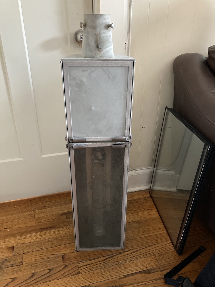
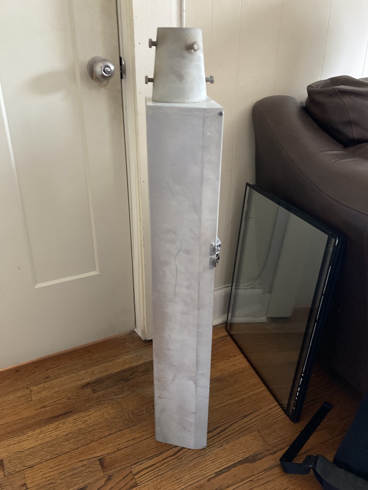
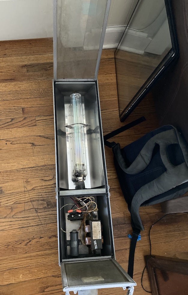
    I bought a retired Escondido, CA low-pressure sodium streetlamp off ebay, replaced the bulb, removed the solar sensor, and four years after I started: I have the correct glow for my illuminated maps.

    Escondido used these lamps out of consideration for the 200″ Hale Reflecting Telescope on nearby Mt. Palomar. Narrowband emitters are much easier to filter out of your astronomical observations than a broad-spectrum source (e.g. the LED lamp that replaced this fixture).

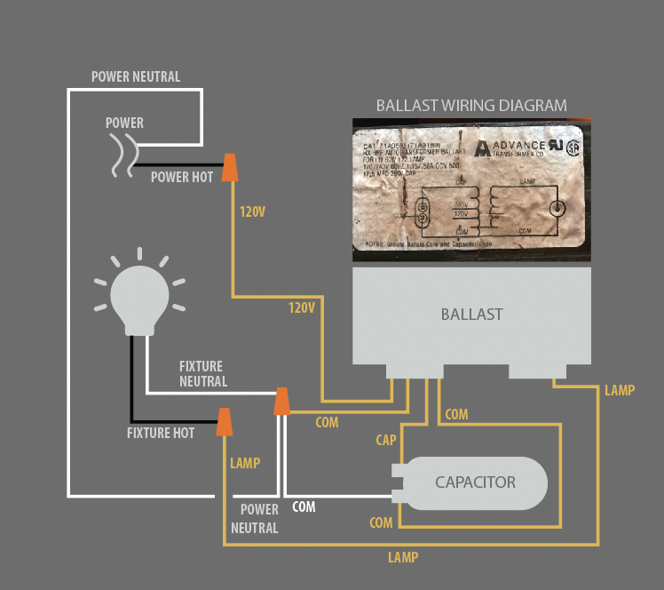
    Here’s how I wired it, ymmv (I don’t advise using my particular power source, a cheap extension cord with the receptacle end ripped off).
    When you first plug it in the lamp glows shocking pink; the sodium on the electrodes hasn’t yet reached vaporization temp, so all flux is coming from the ionized neon in the tube.
    Now we’re cookin: 90 seconds later the sodium has vaporized, we’re glowin at 589nm. A sickly yellow or a great yellow, depends on who you ask.
    Monochromaticity (sic.) demo: narrow-spectrum low-pressure sodium vs. a wide-spectrum 1800k LED meant to replace it. Notice how the green of the cutting mat is only visible under the LED.
    Using the lamp to backlight a chunk of my 3×5′ world map.

    I first experimented with backlit maps in 2019 when I lived in Silver Lake; the color range of the LPS lamp, hot pink and yellow, cover most of what you’ll see of SoCal emissions.

    A sidewalk buckled by fig roots, pink and yellow pools…I tried to get that low-pressure sodium flux with gels, inkjet-polyester film, tunable RGB LEDs. But there’s nothing like the real thing. I think once the last LPS bulb breaks, that’s the end, no one’s manufacturing any more. But I’ll enjoy my time with my favorite glow while it lasts :^)

  • Cartographic graduate education at the University of Wisconsin–Madison, 2014-2017

    Do not go to grad school unless you’re sick of having a job. If you want to learn how to make nice maps, you’re on your own. Graduate map education = writing dull PDFs about maps, not making nice maps.

    Well why’d you go, dummy?

    I emailed nat geo magazine in 2013 and asked “how do I get hired?” My correspondent said “Most of my colleagues have University degrees in geography, about half at the graduate level.” I had a B.A. in International Relations and was working as a graphics editor at Businessweek. A carto M.S. seemed like a good shortcut.

    In 2013 I could find ~six unis in the U.S. who still awarded master’s degrees in cartography. I took the GRE (170 verbal, 157 quant, 5.0 analytical, 3.5 undergrad GPA), visited University of Oregon, Oregon State University, University of Wisconsin-Madison, and Penn State.

    I applied to University of Oregon, University of Wisconsin-Madison, and Penn State.

    I was accepted into Penn State as a PhD candidate. “Huh? I don’t want a doctorate.” Grad coordinator said “That’s okay, you can get an M.S. as a milestone and drop out afterward.” What? Anyway State C0llege, PA was not my town.

    I was accepted into UW-Madison as an M.S. student with two years’ free tuition, $9k/year stipend. A free degree and I was working remotely on Manhattan wages so I lived like a king. Very lucky!

    Here’s what I saw from September 2014 to January 2017:

    • The bad
      • 10% of miserly $9k/year stipend lost to mandatory “segregated fees,” i.e. “what UW spends to entice teenagers,” i.e. “that rock climbing wall in the student union you never use.”
      • Academics will not hesitate to waste your time.
        • The geography grad studies committee chaired by Prof. Mason told me “your two remote sensing classes don’t count for your breadth requirement, you gotta stay an extra semester and take two more classes to get your diploma.” I appealed and they relented (the student handbook and department head Prof. Naughton were on my side), but it ruined my month.
          • Even the “nevermind” email was █████. “The Committee agreed that the use of these Remote Sensing courses to fulfill the geography breadth requirement for the MS-Cartography/GIS is inconsistent with the original intent of that requirement. However, because our communication about the breadth requirement [i.e. a 90s-era unpublished document that no one had seen before] has not been as detailed as it should be, we also agreed to allow you to use Geog 371 and 372 to meet it with the understanding that we will make sure that the intent of the requirement is clear in the future.” Not my problem!
        • I ask Prof. Zhu to let me test out of “GEOG 377: intro to GIS,” which is just 12 weeks of “can you use ArcMap?” At that time I had used ArcMap professionally. He declines, helpfully explaining that “if GIS students have to take cartography classes, cartography students have to take GIS classes.” I turned in all twelve labs in 3 days. He still required that I attend class (taught exclusively by his RA) and take the final.
        • Prof. Zhu teaches GEOG 578: GIS applications, wherein groups of students pick a topic, write up a GIS analysis and present it to the class. He’s more concerned about your powerpoint aesthetics than whatever argument your “GIS analysis” is making. Learned nothing.
          • This class was so bad I kept a contemporaneous log to dump into the class eval at the end
            • sep 22: had us read pre proposals aloud when they could have been emailed ahead of time
            • mandatory labs are extended lecture hours (i.e. reading slides) with redundant material.
            • slow pace. given clear guidelines and deliverables, our group could have finished our project in 3 weeks instead of 12.
            • sep 29: presented our project concepts. prof scolded us for hewing too closely to directions and for reading our slides, which is what we were instructed to do for the last assignment. hassled us about ppt animations.
            • nov 17: hassled for not following directions closely enough on our progress report, said “any problem is an opportunity to do something fancy,” which is baldly wrong. you do what’s expedient because your time is not unlimited. he hasnt had a job in a while i suspect
            • October 6: lab time, which is mandatory for a full participation grade, used as extended lecture time for our group to do pseudo coding. bad use of time. 
        • Prof. Zhu teaches GEOG 579: GIS and Spatial Analysis, an online-only course. Multiple-choice quizzes comprise all graded work. Most test questions involve linear algebra; I know nothing about linear algebra. I guessed my way to an A-.
      • Prof. Roth teaches “GEOG 370: intro to cartography,” the only cartography class I attended over 5 semesters. Exams required students to memorize a whole lot about map semiotics. Boring! If I wanted to write papers about maps it’s good to know the jargon, but I wanted to make nice maps.
      • I was a TA for Prof. Kang’s softball online breadth course for ~150 teenagers, GEOG 170: Our Digital Globe. I rewrote 3x very undemanding labs.
        • These kids were paying serious money to “attend” a class that asked them to skim ~2,000 words in HTML, email three screenshots, and click “submit” on three multiple choice quizzes. That’s it. I spoke to one out of 150 students; 99% of my TA duties were emails and clicking around in the CMS.
          • During my exit interview with the grad program director I said something like “Students get nothing out of our online classes. It’s lazy on our part too, they don’t see their instructor once.” She said something to the effect of thanks for the input, the department will offer way more online classes.
    • The good
      • Prof. Schneider and TA Ryan Sword offer two rigorous classes on using orbital spectroradiometers to make educated guesses about gross earth surface trends (“environmental remote sensing”).
        • Prof. Schneider didn’t have a lot of spare time, but she spent a good amount of it ensuring I graduated: she heard I dropped my other remote sensing thesis, emailed “you’re good at RS don’t quit,” gave me a softball ML + remote sensing project of her own design that I could turn into a 70p PDF. I trained C4.5 on a bit of training data and used it to find “urban land cover change” in 90x landsat tiles covering Laos (there is no urban land cover change in Laos). It was something a bright undergrad could do. I was not her student, not paid out of her bucket, just a guy who took her classes. It was a true out-of-the-blue kindness that I could not repay; I gave her husband my bicycle when I graduated and moved away.
      • Non-faculty (but worth 100 of them) Tanya Buckingham managed the cartography lab, a cozy attic with old desks and old computers. If you were an undergrad or grad student who wanted to learn to make National Geographic-quality maps (like she did), she would provide close-range training and guidance. If you were faculty and need a nice map for your poster sesh, she’d pair you with a good cartographer. Even if you were not affiliated with UW-M and you needed a map, she’d find you a cartographer. She provided the one space in the UW-Madison geography department where you could learn the craft of mapmaking. She provided a desk to cartographer Daniel Huffman; if not for her, I wouldn’t have been able to sit next to Daniel for 18 months and benefit from his instruction. I was starving, Tanya was the soil, Daniel was the barley.
        • Tanya steered me into National Geographic Magazine as a 2015 summer geography intern. I published five pages of maps across two issues. I got unimpeachable portfolio cred, hit the summit thanks to Tanya! Couldn’t have asked for more.
      • Daniel Huffman was the only person at UW-Madison besides Tanya interested in making and teaching beautiful maps. His instruction extends to at all ranges: Daniel writes thorough tutorials for his site. He taught the GEOG 370 introductory cartography class when the main prof was unavailable. I even saw him teach an impromptu “let’s go from confusing database to nice shaded relief” class for anyone who was hanging around the cartography lab that day.
        • Most important, Daniel tolerated my stupid questions for 2 years and taught me, elbow to elbow, how to make beautiful maps. I’m not as generous as Daniel. I don’t write tutorials. I don’t provide good feedback on twitter. I don’t edit cartographic journals, or give actually-useful conference presentations, or let people watch me work. Few have his generosity and talent. In word and deed he wants to make more map makers. He has never stopped saying “cartography is not magic, it is practice, and you have to start practicing.” A real blessing, I hope to propagate at least 1% of that spirit.
      • Every Friday emeritus (nay, ancient) Prof. Tuan would shuffle down to the weekly guest lecture. Tuan is apparently a legendary geographer, I dunno I’ve never read his stuff. The guests were PhD candidates from other unis who’d click through a PPT about Baltimore crime or soil science or Bangladeshi labor migration (academic geography is an overlarge tent.) At the end Prof. Tuan would always ask a sixty-second probing philosophical question about their field. Every presenter was befuddled, totally caught out. I dunno why but it made me smile; if you’re gonna be in the academy, be an Academic, not a button pusher or powerpoint chimp.
      • Because the UW-Madison M.S. Cartography & GIS program was 10% as demanding as my Manhattan office job, I had time to barbell 5×5 in UW’s sweet gym with twelve squat racks. Gained 15lb of muscle in 20 months.
      • One of the lavish student unions had a real theater that screened movies a few times a week. I got to see Apocalypse Now for the first time on a 30ft screen with a Trader Joe’s bag full of popcorn I brought from home.
      • The USGS paid for my flight to the 2015 ICA conference in Rio de Janeiro. Conference sucked, stood by my poster on making editorial maps for 45 minutes, spent the rest of the trip in Brazilian sunshine.
      • Horticulture club: pruned an apple tree (badly), met some bees, cover cropped the student farm with rye, attended 2x Midwest Organic Farming Conferences in La Crosse for free. It was great, learned about mechanical weed control, how to handle powdery mildew, integrated pest management (predators….), other stuff I’ll never use because farming is hard. The conferences were great because 1) none of the computerguy conferences I’d attended had healthy, ruddy people 2) tables covered in organic cheese, apples and nuts 3) learned to contra dance.
      • At university you can learn whatever you want: I’d attend class, do my assignments at the library, then sit in other departments’ guest presentations. I learned that 17% of insurance buyers eligible for flood coverage actually buy it (59% of customers for eligible for terrorism insurance actually buy that), traditional Mongolian liquor is distilled from big vats of yogurt, e coli strains 0157 and 0104 are dangerous because they excrete shigatoxin, a gene they picked up from phages that reproduced lysogenically inside shigella bacteria, and then the phages then incorporated their genomes into e coli on the next infection cycle, larval chrysomelidae beetles eat bergamot (usually toxic to bugs) and collect their shit into a little club that repels predators, axolotls evolved in niches with very little iodine, the fur of 3-toed sloths hosts an algae that grows nowhere else (the sloths lick the algae off), pawpaw flowers smell terrible because they’re pollinated by carrion insects like beetles and flies, spiny water flea ruined Lake Mendota by eating all the daphnia (daphnia eats algae, which keeps the water clear), leaf cutter ants don’t eat the leaves but instead carry them to their colony’s fungus garden, and then the ants eat the fungus, but the fungus gets attacked by a smaller fungus, so the ants carry bacterial colonies on their bodies that feed off a gland on the ants, an the bacteria kill the bad fungus that kills the good fungus, and so on.

  • Absurdly baroque map projects

    • Call the same quarry The Getty used. Mound up the blocks into ziggurat, empty middle. The top is a sheet of water-clear fused quartz. More 40 feet down: quartz, film map, repeat. Low-presh-sodium-style lighting shines from the bottom. 90-deg mirrored telescopes on casters; roll them around to peer into the depths.
    • One of the private squares in the UT/NV/CO/AZ PLSS checkerboard. Find a 20ft slot canyon. Fill with glass.
    • Map garden: pick a well-drained two-acre site. Hire a local gray ponytail to plant it for you, real thick. Anchor in glowing maps, stone maps, milled-brass maps, stamped copper maps. Wait 5 years for the landscaping to eat the edges of your maps, for tiny plants to fill the gaps between the flagstones.
  • The mapmaker’s terrible hand

    Effacing features is a rush. The “critical cartographers” have one good point they bury in recondite academese: the mapmaker has absurd power.

    Nice town or flyspeck island community you got there. Where everyone you’ve ever cared about weaves a rich tapestry of comity and care. Just seeing the tiny smudge of roads on the map surfaces memories…the creaky springs on the dry goods shop door….the proprietor’s old dog splayed in the doorway, indifferent to traffic……

    All that important stuff? All those lives lived in that patch of ink? All those long driveways hazed by bonfire smoke? The feel of the cold bottle in your hand as you head around back?

    Occludes a label I need, so: annihilated. Gone. Never existed. You’ve been generalized.

    What you care about is not on the map? Guess you gotta make your own

  • The best maps lie ahead

    Read more: The best maps lie ahead

    Luckily we just need millions of dollars and thousands of hours.

    TLDR

    I want to see another Turgot map before I die. I want my grandkids to cherish a map made in the 2030s. I want some of the most beautiful examples of western material culture to live on. I can’t do it alone.

    Would anyone want this on their wall 50 years from now?

    In 1910 you could buy a 5 cent rail route pamphlet that looks better than any map you can buy today. This sucks, but it could not be otherwise; consider who makes today’s maps:

    • Atlas cartographers: mostly gone, those who remain can’t pick colors
    • GIS managers: their job is to manage the sewer pipe/streetlamp database and make maps for 8.5×11″ PDFs, can’t design or don’t have time
    • Editorial/news cartographers: under tight deadlines, editors don’t care, art directors don’t discourage nice maps but they also don’t know how to shape or commission them
    • Government cartographers, from muni cadastral to fedgov: almost all GIS managers, the maps just gotta reflect the database, nobody cares how they look. National Park Service maps excepted.
    • Nonprofit cartographers: too busy with GIS tasks, boss doesn’t care about nice maps
    • Big tech cartographers: Google/Apple’s maps are database outputs, too constrained by users poking at the map to make them look nice
    • Academic/critical cartographers: not rewarded for making nice maps, rewarded for writing recondite PDFs about maps
    • Capital A Artists: too into deconstruction to make a sincere attempt
    • Biz intelligence cartographers: who’s gonna cherish a bunch of hex bins?

    There are exceptions within those categories, but I’m being appropriately strict: “Would anyone want to hang this on their wall 50 years from now?

    The only good cartographers are illustrators; in their maps gestalt and composition come first. And they don’t just affirm the software’s idea of how a map should look.

    This is not permanent.

    Every beautiful high-production-value map you’ll see in a repository: it can be made today, maybe better. They had “time, strength, cash, patience,” but while attenuated, those things are still around; some patron could pay an illustrator to walk around a city for years and draw every building he saw, like the Prévôt des Marchands of Paris did in 1734.

    The bad news is there is no living memory of this stuff, no old hands to teach how the past’s rich maps were constructed. We start from scratch. The good news is we know exactly what to aim for.

    What is to be done?

    There’s no building you can walk into where someone will grab you by both ears and teach you how to make a beautiful map. Formal cartography education does not exist in the US; I have a (free) MS in cartography and almost all of the looks-nice mapmaking I did was extracurricular.

    Today’s talented anglophone mapmakers, and there are many, taught themselves. They are the only ones taking this seriously; the autodidacts are my favorite. I just wish you didn’t have to be a five-star autodidact to make nice maps.

    This is solved with ~$15 million, property, and professional instruction: make more map makers by apprenticeship. I learned mapmaking by close-range apprenticeship; so, a school with a 1:1 instructor ratio.